Are you curious about the mysteries behind GOES satellite frequencies? Look no further. In this comprehensive guide, we will delve into the fascinating world of GOES (Geostationary Operational Environmental Satellite) and uncover the secrets of its frequencies.
GOES satellites play a crucial role in weather forecasting, climate monitoring, and overall Earth observations. Understanding how their frequencies work is essential for professionals in meteorology, telecommunications, and other related industries.
In this article, we will explore how GOES satellites transmit and receive signals, the different frequency bands they use, and the significance of each band in gathering accurate and reliable data. Discover the importance of GOES satellite frequencies in ensuring seamless communication across the globe, supporting disaster management initiatives, and enabling advanced weather prediction models.
Whether you are a weather enthusiast, a scientist, or simply curious about satellite technology, this guide will provide you with an in-depth understanding of GOES satellite frequencies. Stay tuned as we unravel the secrets that these frequencies hold and reveal how they contribute to our knowledge of the world around us.
What is satellite frequency?
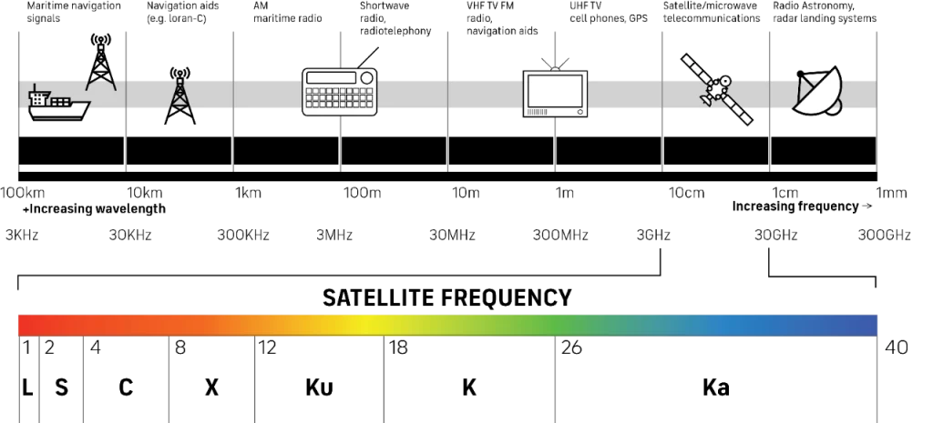
Satellite frequency refers to the specific range of electromagnetic waves used for communication between satellites and ground stations, as well as between satellites themselves. These frequencies, measured in hertz (Hz), play a critical role in the transmission of data, voice, and video signals. In the context of satellites, frequency ranges are divided into bands, which are categorized based on their wavelengths and propagation characteristics. The proper use of these frequencies ensures effective communication and data transfer, making it a fundamental aspect of satellite technology.
The electromagnetic spectrum encompasses a wide range of frequencies, each suited to various applications. For instance, lower frequency bands tend to penetrate the atmosphere better but offer lower data rates, while higher frequency bands provide higher data rates but are more susceptible to atmospheric conditions such as rain and clouds. Understanding satellite frequency is essential for optimizing communication systems and ensuring reliable performance, especially in missions reliant on accurate data transmission, such as those conducted by the GOES satellites.
In the case of the Geostationary Operational Environmental Satellites (GOES), frequency usage is vital for meteorological observations and environmental monitoring. GOES satellites operate in specific frequency bands allocated for weather-related data, allowing for real-time communication of critical information. The careful management of these frequencies ensures that data collected from GOES satellites can be transmitted efficiently and received accurately by meteorologists and researchers worldwide.
Understanding the different frequency bands used by GOES satellites
GOES satellites utilize several frequency bands to collect and transmit data, each tailored for specific types of observations and communications. The primary bands used by the GOES system include the visible, infrared, and microwave bands. The visible band captures data in the range of approximately 0.4 to 0.7 micrometers, which is crucial for monitoring cloud cover, vegetation, and surface conditions. This band allows meteorologists to assess weather patterns and track storms, providing vital information for forecasting.
The infrared bands, which operate in the 3 to 14 micrometers range, are essential for detecting temperature differences in the atmosphere. These frequencies help in monitoring cloud heights, sea surface temperatures, and thermal radiation emitted from various surfaces. Infrared observations are particularly valuable during nighttime when visible light is unavailable, allowing continuous monitoring of weather systems. By analyzing temperature variations, meteorologists can identify and predict severe weather events, enhancing public safety.
Additionally, GOES satellites employ microwave frequencies, typically in the range of 1 to 100 gigahertz (GHz). These frequencies are particularly important for precipitation detection and atmospheric profiling. They penetrate clouds and other atmospheric obstructions, providing data on moisture content and storm development. The combination of these frequency bands enables comprehensive monitoring and analysis of weather patterns, contributing to improved forecasting accuracy and response efforts during natural disasters.
The importance of GOES satellite frequency in weather forecasting
GOES satellite frequency plays a pivotal role in weather forecasting by facilitating the continuous transmission of real-time data to meteorologists and climate scientists. The ability to monitor atmospheric conditions, cloud formations, and temperature variations is essential for predicting weather changes. Accurate forecasting relies on the timely collection and dissemination of data, which is made possible through the effective use of satellite frequencies. Without these frequencies, the data collected would be limited, leading to less reliable forecasts.
The information transmitted by GOES satellites includes images and data on various atmospheric parameters, which are crucial for predicting severe weather events such as hurricanes, thunderstorms, and tornadoes. The frequencies allow for high-resolution imaging and rapid data updates, enabling meteorologists to track the development of these systems and issue warnings when necessary. This timely communication is vital in disaster management, as it can save lives and mitigate damage by providing advance notice to affected populations.
Furthermore, the use of GOES satellite frequencies supports climate monitoring and research. By analyzing long-term data trends, scientists can better understand climate change and its impacts on weather patterns. The continuous stream of data provided by GOES satellites enhances our understanding of atmospheric processes, enabling more accurate climate models. Consequently, the importance of GOES satellite frequency extends beyond immediate weather forecasting; it plays a significant role in our overall comprehension of Earth’s climate system.
Several factors can influence the reception of GOES satellite frequencies, impacting the quality and accuracy of the data received. One primary factor is atmospheric conditions, which can attenuate signals transmitted from satellites. Rain, snow, and fog can absorb or scatter the electromagnetic waves, leading to weaker signals and potential data loss. Understanding the effects of these atmospheric phenomena is crucial for ensuring reliable communication and data transmission.
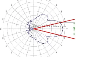
Another significant factor is the geographic location of the receiving ground station. The elevation and terrain can obstruct signals, particularly in mountainous or densely populated areas. Additionally, the distance from the satellite can impact signal strength; greater distances may result in weak signals that are difficult to decode. Ground stations equipped with high-gain antennas can help mitigate these issues by focusing on incoming signals, thus improving reception quality.
Interference from other electronic devices can also disrupt the reception of GOES satellite frequencies. This interference may originate from terrestrial communications, industrial equipment, or even other satellites operating within similar frequency bands. Effective frequency management and coordination are essential to minimize these disruptions, ensuring that the data transmitted from GOES satellites is received accurately and without distortion.
Equipment and techniques for receiving GOES satellite frequency
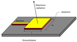
Receiving GOES satellite frequencies requires specialized equipment capable of capturing and decoding the signals transmitted from these satellites. The primary component is the antenna, which must be appropriately sized and oriented to receive the specific frequencies used by GOES satellites. High-gain antennas are commonly employed to enhance signal reception, providing the necessary sensitivity to capture weaker signals, especially during adverse weather conditions.
In addition to antennas, a receiver is essential for processing the incoming signals. These receivers convert the electromagnetic waves into digital data that can be interpreted and analyzed. Modern software-defined radios (SDRs) are increasingly popular for this purpose due to their flexibility and ability to be programmed for various frequency bands. These devices allow users to tune into specific frequencies and filter out noise, improving the clarity of the received data.
Effective techniques for receiving GOES satellite frequencies also include the use of signal processing algorithms to enhance data quality. These algorithms can correct for distortions caused by atmospheric interference and improve the overall accuracy of the received information. Data visualization tools further aid in interpreting the received signals, allowing meteorologists and researchers to analyze the data effectively. By combining the right equipment with advanced techniques, users can maximize the potential of GOES satellite frequencies for weather monitoring and research.
How to decode and interpret GOES satellite frequency signals
Decoding and interpreting GOES satellite frequency signals is a crucial process that transforms raw data into actionable information. The first step in decoding involves demodulating the signals received from the satellite. This process separates the data from the carrier frequency, allowing the extraction of the information encoded within the signal. Various modulation techniques, such as Frequency Shift Keying (FSK), are commonly used in GOES satellite communications, requiring specific algorithms for successful decoding.
Once demodulated, the data must be parsed and organized for interpretation. GOES satellites transmit a variety of data formats, including images, numerical data, and meteorological parameters. Software tools designed for satellite data processing are employed to handle these different formats, enabling users to convert the raw output into usable information. These tools can also perform additional tasks, such as calibrating the data to account for atmospheric effects and enhancing image quality.
Interpreting the decoded data involves analyzing the meteorological information to derive meaningful insights. Meteorologists utilize advanced visualization techniques to create images and maps that represent weather conditions. These visualizations help in identifying patterns, such as storm development and precipitation areas, and are essential for making informed forecasting decisions. By leveraging technology and analytical skills, users can transform GOES satellite frequency signals into critical information that supports weather monitoring and decision-making.
Applications and uses of GOES satellite frequency data
GOES satellite frequency data is invaluable for a wide range of applications beyond traditional weather forecasting. One primary use is in severe weather monitoring. GOES satellites provide real-time data on storm development, enabling meteorologists to track hurricanes, tornadoes, and other severe weather phenomena. This information is crucial for issuing timely warnings and advisories, ultimately saving lives and minimizing property damage during extreme weather events.
In addition to severe weather monitoring, GOES satellite data plays a significant role in climate research. Long-term satellite observations contribute to climate modeling and understanding atmospheric trends. By analyzing changes in temperature, cloud cover, and other parameters over time, scientists can assess the impacts of climate change on weather patterns and ecosystems. This information is vital for developing strategies to mitigate climate-related risks and adapt to changing environmental conditions.
Furthermore, GOES satellite frequency data is utilized in various sectors, including agriculture, aviation, and disaster management. In agriculture, satellite data helps monitor crop health and assess soil moisture levels, aiding farmers in making informed decisions about irrigation and planting. In aviation, GOES data provides critical information for flight planning and safety, particularly during adverse weather conditions. Additionally, disaster management agencies rely on GOES satellite data to coordinate response efforts during natural disasters, ensuring that resources are deployed effectively and efficiently.
Challenges and limitations of working with GOES satellite frequency
While GOES satellite frequency technology has revolutionized weather monitoring and forecasting, it is not without its challenges and limitations. One significant challenge is the reliance on accurate calibration of instruments. Any errors in calibration can lead to inaccurate data, which may result in flawed forecasting and analysis. Maintaining precise calibration requires regular maintenance and updates to equipment, which can be resource-intensive and complex.
Another limitation is the finite bandwidth available for satellite communications. As the demand for satellite data increases, the available frequencies become crowded, leading to potential interference and signal degradation. Managing these frequencies is essential to ensure clear communication and data transmission. Furthermore, advancements in technology and the growing number of satellites can exacerbate these issues, necessitating ongoing efforts to optimize frequency usage and minimize interference.
Additionally, atmospheric conditions pose a constant challenge for GOES satellite frequency reception. While advancements in technology have improved signal processing capabilities, adverse weather conditions such as heavy rain, snow, or fog can still affect data quality. This limitation underscores the need for continuous research and development to enhance the resilience of satellite systems and improve their performance in challenging conditions.
Conclusion and future developments in GOES satellite frequency technology
In conclusion, understanding GOES satellite frequency is essential for harnessing the full potential of these critical tools in meteorology and environmental monitoring. The intricate interplay of frequency bands, data transmission, and reception techniques enables accurate weather forecasting, climate research, and disaster management. As technology continues to evolve, so too will the methods employed to utilize GOES satellite frequencies effectively.
Looking ahead, future developments in GOES satellite frequency technology will likely focus on enhancing data collection capabilities and improving signal resilience. Innovations in satellite design, such as advanced sensors and improved communication systems, will enable the collection of higher-resolution data and broader spectral ranges. These advancements will support more accurate modeling and forecasting, ultimately benefiting society as a whole.
Furthermore, the integration of artificial intelligence and machine learning into satellite data processing holds great promise for the future. These technologies can enhance data interpretation, automate routine analyses, and identify patterns that may not be immediately apparent to human observers. As we continue to unlock the secrets of GOES satellite frequency technology, we can anticipate improvements in our understanding of weather patterns and climate dynamics, paving the way for a safer and more informed future.

